Spring 2026 Update
Completed
- Two-way separated cycle tracks (pairs of bike lanes) on both north-south internal BART roads (West Drive and East Drive) and on east-west road connecting Acton Street to the station plaza. To accomplish this, we converted West Drive and East Drive to one-way operation for vehicles.
- Two-way cycle track on north side of Delaware Street between Acton Street and Sacramento Street.
- A speed table and a raised crosswalk in front of the station entrance and raised crosswalks across Franklin St and across Delaware St at midblock.
- New ADA-accessible passenger loading zone on southbound Sacramento Street protected by the midblock sidewalk extension and a direct connection from the street sidewalk to the internal sidewalk that leads to the BART platform elevator.
- Ohlone Greenway between Acton/Virginia intersection and Virginia Gardens widened from 10’ to 18’ to allow for separation between a two-way cycle track and a pedestrian-only path.
- Improved diverter at Acton/Virginia intersection to prevent drivers from climbing up the sidewalk to get around the diverter.
- New two-tier bike lockers on the plaza, including space for oversized bikes
- Net new 122 secure bicycle parking spaces.
- Pedestrian-scale lighting within station area and along Ohlone Greenway.
- Landscaping and storm water management.
In Progress
- Art
- Additional signage
- At Franklin, Acton/Virginia, Delaware
- Around the plaza
- Light deflectors along Ohlone Greenway
Scroll through this slideshow to see the improvements ⬇️


Context for the Project
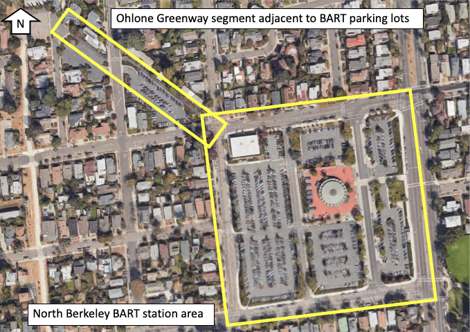
The Ohlone Greenway is a regionally significant trail spanning over 5 miles of shared-use path in 4 jurisdictions (Berkeley, Albany, El Cerrito and Richmond) in two counties (Alameda and Contra Costa). Two segments of the path are adjacent to BART-owned properties currently used as parking lots, as illustrated below.
The infrastructure in these segments before the project improvements was a 10-foot wide multi-use path. Under normal conditions and during peak commute hours, these segments were congested with pedestrians that cyclists prefer to ride through the parking lots. The Ohlone Greenway, in general, is a critical component of the bicycle and pedestrian access infrastructure for BART riders.
The station area itself is very permeable and offers many options for entry/exit for those who drive and park and for those who walk; however, the only infrastructure fully dedicated to cyclists was bike parking in the form of racks and electronic lockers.
This project implemented bicycle and pedestrian access improvements at North Berkeley Station to advance the 2016 Station Access Policy (PDF) goal for Safer, Healthier, Greener and TOD Performance Measures and Targets (PDF) for 52% active access for home origin trips districtwide by 2025. For more information, visit BART's Station Access Policy webpage.
- Reduce congestion in the Ohlone Greenway
- Improve pedestrian safety and security
- Minimize cost and maximize benefit in light of upcoming TOD
Background Data
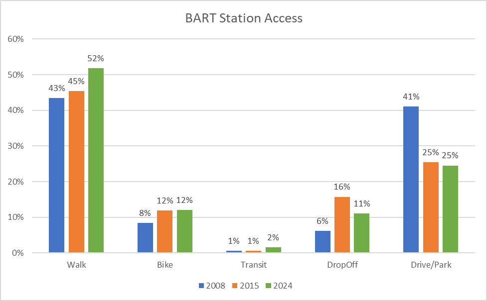
Based on BART's 2024 Station Profile Study survey data, 64% of home-origin trips to North Berkeley station are already made by walking and biking, This is up from 52% in 2008 and 57% in 2018. BART wants to support these trips, and make walking and biking a safer and more attractive option for more people.
Visit the Station Profile Study page for additional information.
Data Collection
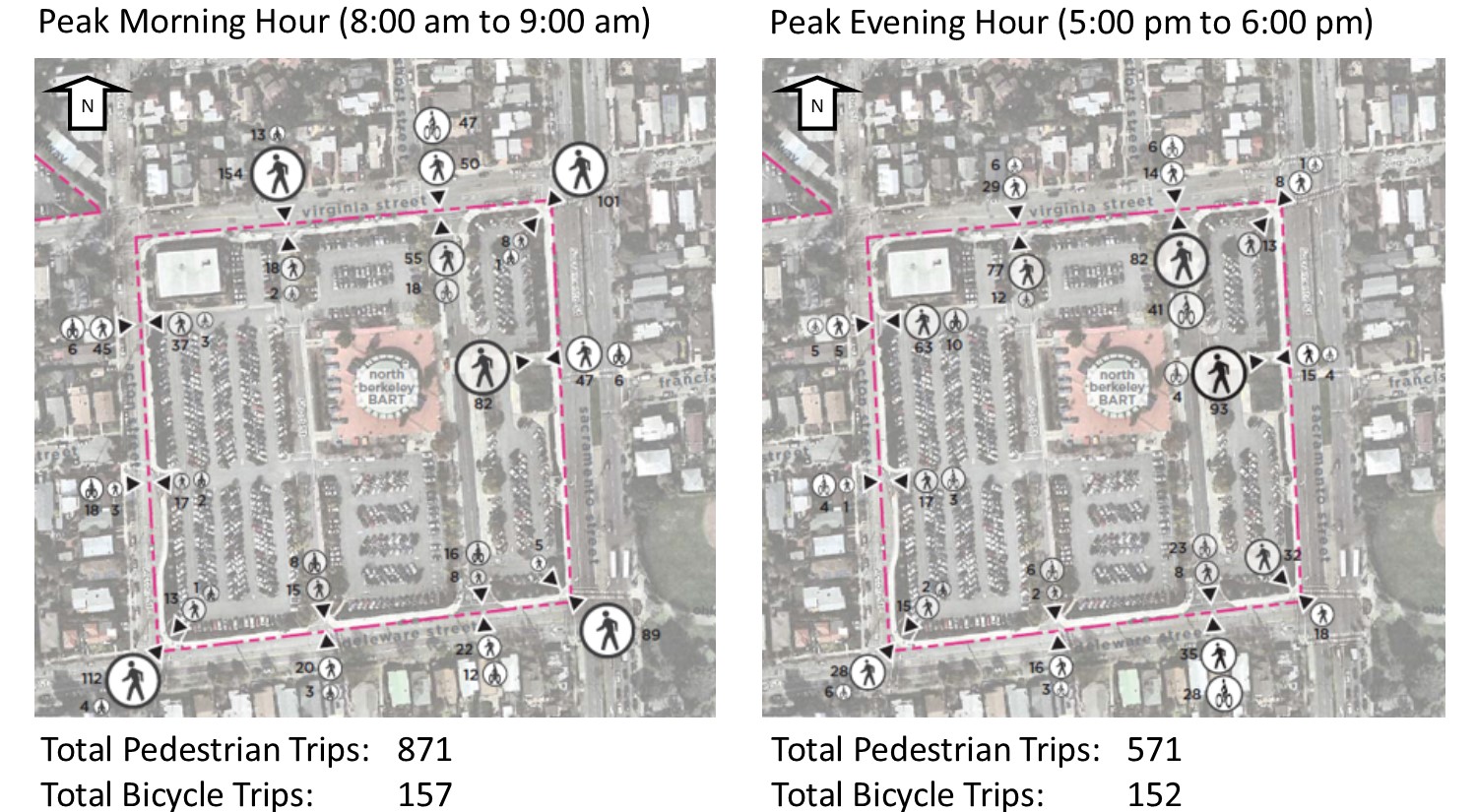
For this project, we collected trip data to/from the North Berkeley station area on typical, middle-of-the-week weekdays in November 2017.
Active Access Trips
Vehicle Trips Trips
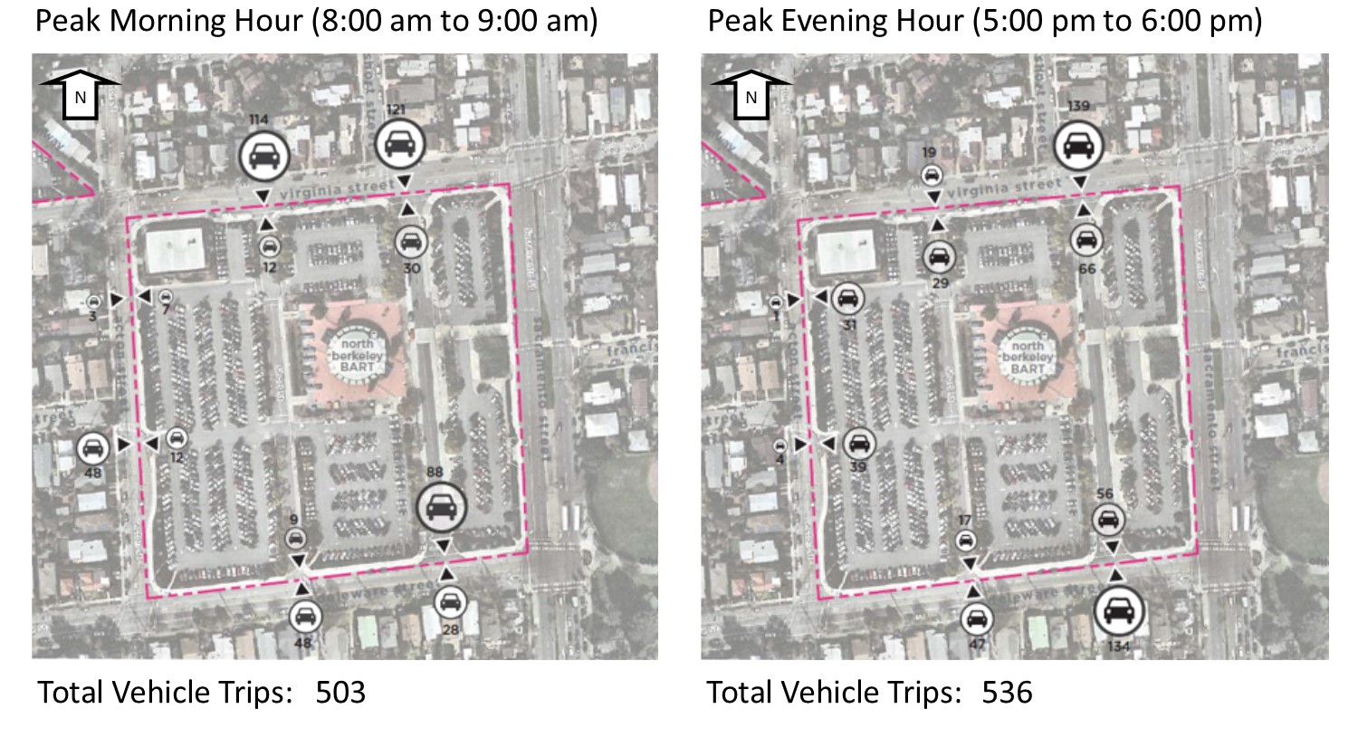
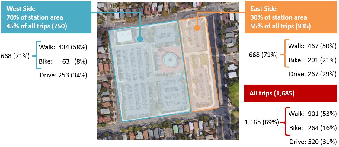
Our data taught us that most people, regardless of mode, arrive/leave the station through a small portion of the station area on the east side, where the station entrance is level with the street - i.e. there are no stairs (illustrated below).
Funding
The project received two grant awards totaling $3.4 million from the Affordable Housing & Sustainable Communities Program (AHSC) in partnership with Bridge Housing and Satellite Affordable Housing Associates (SAHA), which complemented BART voter-approved Measure RR funds for the project.
![]()
Questions?
For more information, contact the Station Area Planning Group Manager, Tim Chan, at [email protected].