Project Background
In June 2016, the BART Board adopted a new Station Access Policy to guide access practices and investments through 2025. Among others, the policy has the following goals:
Safer, Healthier, Greener
Advance the region's safety, public health, and greenhouse gas (GHG) a pollution-reduction goals.
Better Experience
Be a better neighbor, and strive for an excellent customer experience, including on the first and last mile of the trip to and from BART stations.
In 2017, City of Dublin completed the Iron Horse Trail Feasibility Study with a goal to identify improvements along the segment of the Iron Horse Trail between Dougherty Road and the Dublin/Pleasanton BART station that will better connect the Trail to BART, other trails and bikeways, and homes and businesses along the trail. This study followed on other studies and pedestrian and bicycle master plans led by City of Pleasanton and East Bay Regional Parks District, all of which generally recommended these improvements.
BART's Iron Horse Trail Project implements the study recommendations. It is to improve bicycle and pedestrian access to the Dublin/Pleasanton BART Station, with the following goals:
- Close the gap in the Iron Horse Trail so that BART riders can use it for recreation and access the broader network of trails and green spaces in the area
- Advance the 2016 BART Station Access Policy goals (safer, healthier, greener) and targets (52% active access by 2025)
- Separate pedestrian and bicyclist traffic to improve safety and comfort
Recently, the City of Dublin completed construction of a bicycle and pedestrian bridge over Dublin Boulevard and other improvements to the trail segment immediately north of the BART station area that will close another significant gap in the trails network.
Access to Dublin/Pleasanton
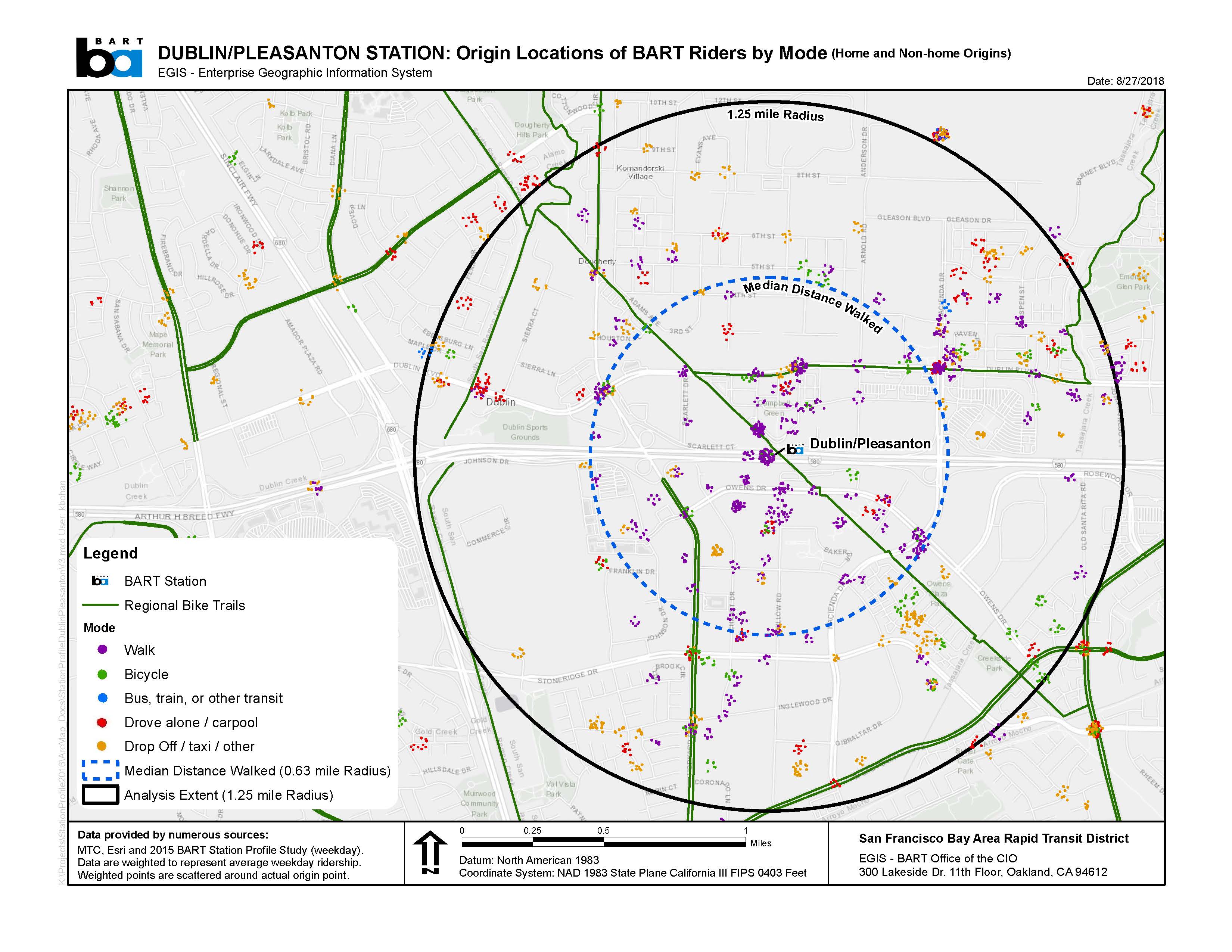
As an end-of-the-line station, Dublin/Pleasanton attracts BART riders from many distant locations, as illustrated in the map below. For these riders, the only really viable options for accessing BART are to drive and park at BART, or to ride a regional bus.
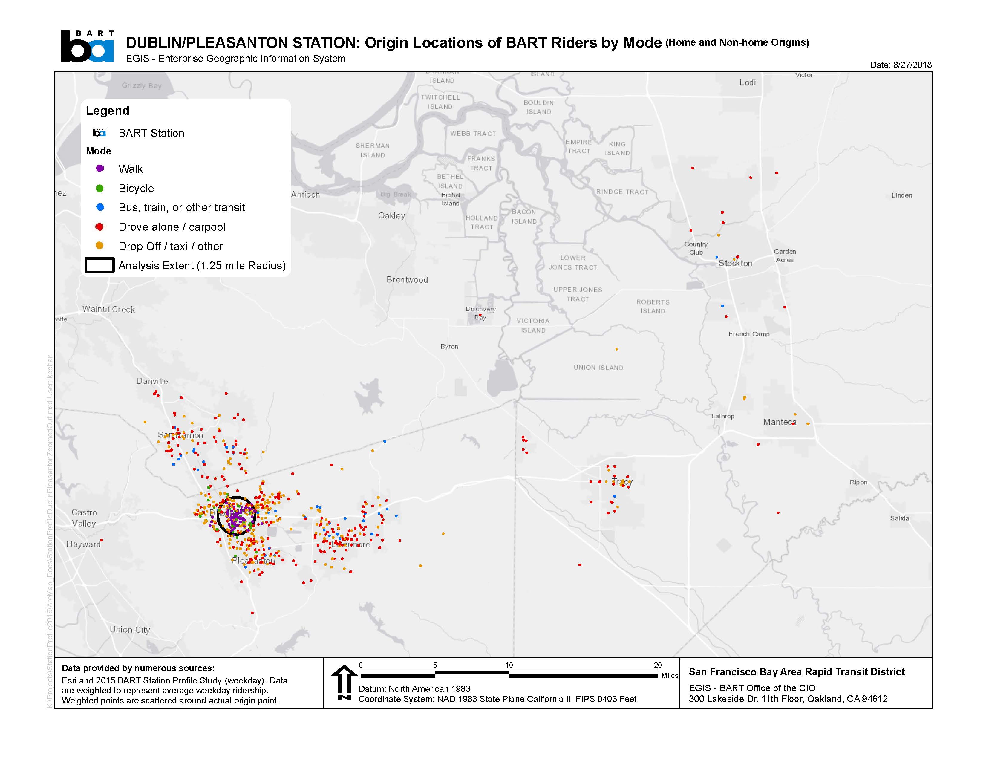
There are, however, many BART riders who walk and bike to and from the station.
The table below shows the breakdown of the mode of access for the Dublin/Pleasanton BART Station in 2015 - the last time BART conducted its Station Profile Study. It also shows how the numbers of people walking and biking to the station have increased since the 2008 Station Profile Study.
Dublin/Pleasanton Station – Average Weekday Station Entries and Mode of Access 2015

There are BART riders who live relatively nearby the station who also drive and park, or get dropped off (see map below), but might choose to walk or bike instead if only they felt safe and comfortable doing so.
Importantly, Dublin/Pleasanton station is also a recreational destination for users of the Iron Horse Trail. During outreach to the community, BART staff heard repeatedly the difficulty of locating the Iron Horse trail from the Dublin/Pleasanton BART Station entrance; there is nothing to indicate where it is located and where it goes. BART’s pedestrian/bike improvement project would support recreational trips on the trail, including for users who take BART to the trail and for existing users who bike and walk on the trail to BART.
The project aims to make walking and biking to and from BART a better, more attractive option for more people who can and want to walk and bike.
Scope of Work - BART's Iron Horse Trail Project
The scope of work for the project includes the following:
- A two-way bicycle track separated from vehicle traffic and from the pedestrian sidewalk
- Pedestrian-scale lighting
- Improved lighting under the freeway and aerial BART structures
- Additional secure bicycle parking
- Wayfinding and signage
- Landscaping and storm water management features
- Safety and security features
- A small park/plaza/gateway treatment at the transition to the Iron Horse Trail to the north
- Public art panels
Design
The images below illustrate the details of the design.
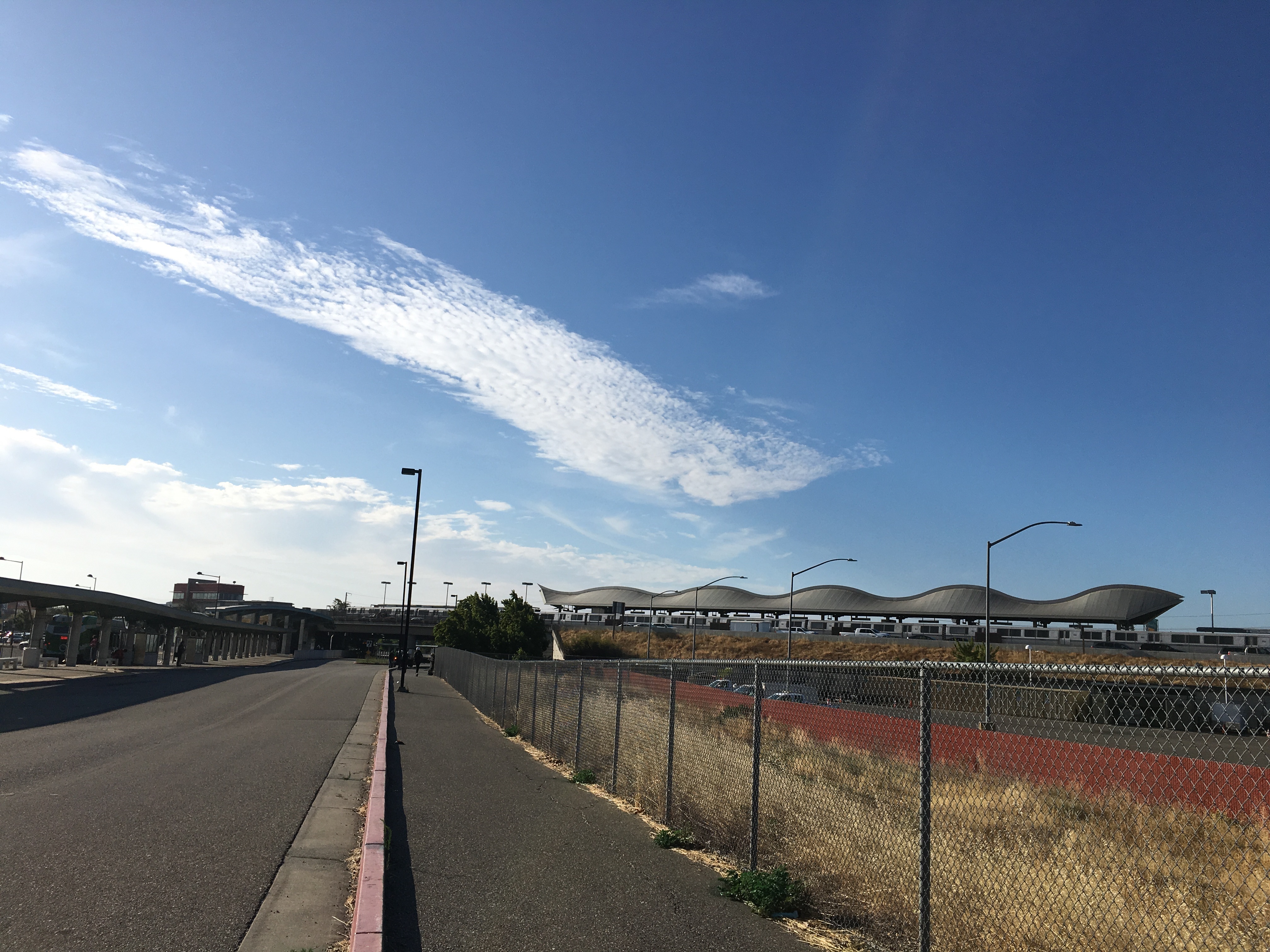
Existing Iron Horse Trail - View of Dublin/Pleasanton Station from the north
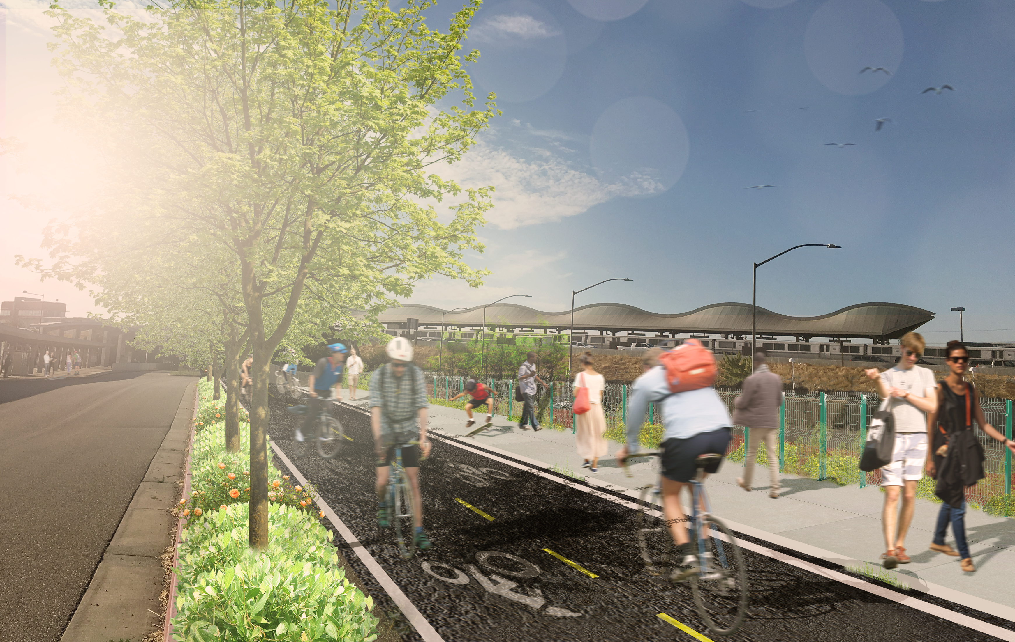
Proposed Iron Horse Trail Improvements – Photo rendering illustrating landscaping, two-way bicycle track, and separate pedestrian sidewalk
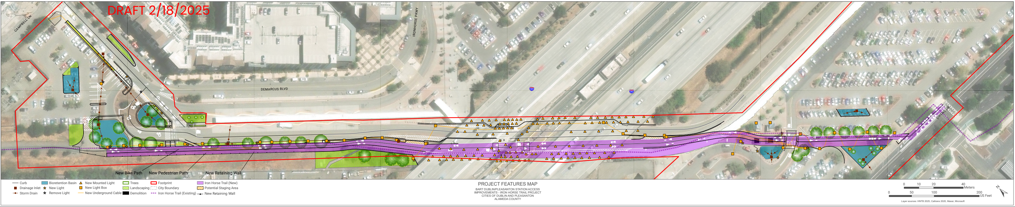
Click here or on the plan for a closer look at the continuous graphic. Click here for a printable version of the plan with page breaks. You can also view a final condition site plan here.
The bicycle lanes vary in width from a minimum of 5 ft. per lane each direction to a maximum of 14 ft. depending on location along the trail. Click here to see cross section drawings.
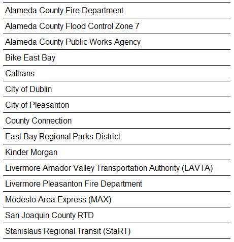
Stakeholders
BART has been coordinating and working closely with several key external stakeholders on this project, including:
Feedback
Have feedback? We'd love to hear from you. Please email us at [email protected]
![]()

Project brought to you by voter-approved Measure RR funds.